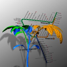
It might seem like a tomato plant and a subway system don’t have much in common, but both, it turns out, are networks that strive to make similar tradeoffs between cost and performance.

Using 3D laser scans of growing plants, Salk scientists found that the same universal design principles that humans use to engineer networks like subways also guide the shapes of plant branching architectures. The work, which appears in the July 26, 2017, issue of Cell Systems, could help direct strategies to increase crop yields or breed plants better adapted to climate change.

Read more ...

When the NASA-NOAA Suomi NPP satellite passed over the Eastern Pacific Ocean on July 25 it captured a visible close-up of Hurricane Hilary.

The Visible Infrared Imaging Radiometer Suite (VIIRS) instrument aboard the NASA-NOAA Suomi NPP satellite captured a visible light image of Hilaryon July 25 at 5:54 p.m. EDT (2154 UTC). The Suomi NPP image showed that Hilary appeared somewhat asymmetric.

Read more ...

Tropical Storm Nesat formed early on July 26 just east of the Philippines and NASA's Aqua satellite passed overhead gathering temperature data to determine the location of the most powerful storms. Imagery showed strong storms from Nesat's western side were affecting the central Philippines.

Infrared satellite imagery from the Atmospheric Infrared Sounder or AIRS instrument that flies aboard NASA's Aqua satellite taken on July 26 at 0529 UTC (1:29 a.m. EDT) provided a look at the temperatures of Nesat’s clouds. That data was false colored and made into an image at NASA's Jet Propulsion Laboratory in Pasadena, California to highlight cloud top temperatures.

Read more ...

A new study found that Caribbean staghorn corals (Acropora cervicornis) are benefiting from “coral gardening,” the process of restoring coral populations by planting laboratory-raised coral fragments on reefs.

The research, led by scientists at the University of Miami (UM) Rosenstiel School of Marine and Atmospheric Science and partners, has important implications for the long-term survival of coral reefs worldwide, which have been in worldwide decline from multiple stressors such as climate change and ocean pollution.

Read more ...

NASA's Aqua satellite provided a near-infrared look at Typhoon Noru as it continued its western track at sea, far to the southeast of Japan.

Near-infrared satellite imagery from the Atmospheric Infrared Sounder or AIRS instrument that flies aboard NASA's Aqua satellite taken on July 26 at 0211 UTC (July 25 at 10:11 p.m. EDT) showed provided a look at the temperatures of Noru’s clouds. That data was false colored and made into an image at NASA's Jet Propulsion Laboratory in Pasadena, California to highlight cloud top temperatures.

Read more ...

More Articles ...

Subcategories